
Finding People on a West Virginia Street
For a West Virginia street directory search, keep one address in view while moving from the parcel to records tied to it. The property roll is the first stop for the assessed owner and parcel number. The map then helps distinguish that lot from nearby land, while a deed index can show a transfer. Voter data and older directories add dated address evidence, but neither proves who is inside a home now. Each record answers a narrower question than “who lives here.”
- Search the West Virginia assessment site by county and street name, then note the parcel ID and physical address.
- Open that parcel in the West Virginia Property Viewer and check its map position and detail panel.
- Use the West Virginia County Clerk index to follow the owner name and legal description through recorded deeds.
- For a dated resident clue, check the West Virginia voter record or a directory for the relevant place and year.
- If an online record ends, ask the county custodian or consult the archive and library holdings.
Repeat this chain for each parcel along the street. Keep a note of the county, district, map, parcel, search date, and source, so a similar name or neighboring lot does not blur the trail.
West Virginia Street Records by Address
A West Virginia street directory search draws on several record sets, but they do not form a single household roll. The owner and situs address come from assessment records; deed, permit, voter, and directory sources add different dates or context. A street name can tie searches together, while parcel IDs and legal descriptions help keep each lot distinct.
| Record group | Custodian | Street detail | Access route |
|---|---|---|---|
| West Virginia assessment / land book | County assessor and WV Tax Division | Owner, parcel, physical and mailing addresses, classification, values | State search, county assessor directory, or counter |
| West Virginia parcel map | WV GIS Technical Center and Tax Division | Parcel shape, address labels, flood and reference layers | WV Property Viewer |
| West Virginia deed index | County Clerk of the County Commission | Grantor, grantee, date, book/page, legal description, image when available | Cott or RECORDhub, terminal, record room |
| West Virginia voter data | County Clerk and Secretary of State | Registered name, residence address, status, party, registration date | Three-field status check or purchased list |
| West Virginia local permits and code | Local building, planning, or code office | Address, work or violation, date, and sometimes applicant | Local page or records request |
| West Virginia directories | Libraries, State Archives, and WVRHC | Dated occupants, businesses, and address context | Onsite, microfilm, or licensed access |
When a West Virginia online result is thin, the county office remains the authoritative fallback. County-specific certified dates control deed coverage, local assessors handle corrections, and old images or books may sit in a record room or an archive rather than on a public search screen.
Send offline requests to the county custodian with the record type, names or address, date span, and format, using the West Virginia FOIA request route. The law allows actual reproduction costs, not search or retrieval labor, and sets a five-day response limit excluding weekends and legal holidays.
West Virginia Street Search Fields
West Virginia's assessment search has Basic, Appraisal/Sales, Advanced, and Prior Ownership modes. Narrow a street search by county first, since the portal combines records from all 55 counties and field quality or refresh notices can vary locally. The West Virginia Property Search is free to use and offers a CSV export for manageable result sets.
The West Virginia property search screen shows the available filters before a query. Its visible fields are useful when one address has been shortened or indexed in more than one way.
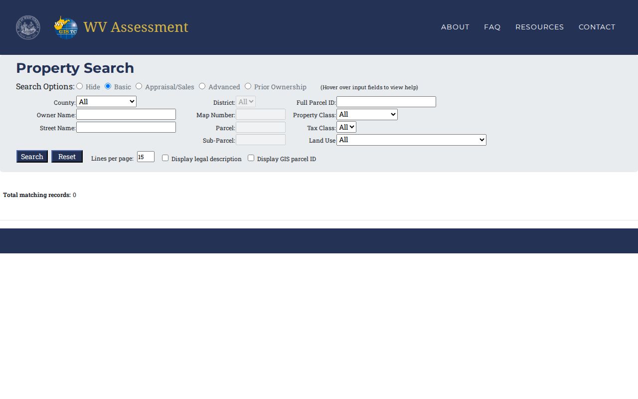
Use the filters below to narrow the search; exact property-class and land-use choices depend on the county data.
| Portal | Field or control | Type | Required | Notes |
|---|---|---|---|---|
| West Virginia assessment search | County; District | Dropdown | Optional | County narrowing is useful for street and owner searches. |
| West Virginia assessment search | Full Parcel ID | Text | Optional | Hyphenated identifier accepted in viewer guidance. |
| West Virginia assessment search | Owner Name | Text | Optional | Partial values allowed; use LASTNAME FIRSTNAME. |
| West Virginia assessment search | Street Name | Text | Optional | Physical-address data can be incomplete. |
| West Virginia assessment search | Map Number; Parcel; Sub-Parcel | Text | Optional | Search identifier components. |
| West Virginia assessment search | Property Class; Tax Class; Land Use | Dropdown | Optional | Codes and exact choices vary with county data. |
| West Virginia assessment search | Search mode | Tabs/buttons | Optional | Basic, Appraisal/Sales, Advanced, Prior Ownership. |
| West Virginia Property Viewer | E-911 address | Text | Optional | Use street address, city, WV; no rural routes or PO boxes. |
| West Virginia Property Viewer | Parcel attributes | County selector and text fields | Optional | County, owner, property address, parcel number, or parcel ID parts. |
| West Virginia Property Viewer | Geometry or coordinates | Map drawing; latitude/longitude | Optional | Point, rectangle, polygon, or buffer; coordinate search uses both values. |
| West Virginia County Clerk index | Index Type; document kind | Dropdown | Optional | Exact choices depend on county. |
| West Virginia County Clerk index | Book; page; suffix; date filed or date range | Text/date controls | Optional | Use known record references or filing window. |
| West Virginia County Clerk index | Grantor; grantee; description | Text | Optional | Search both parties and the land text. |
| West Virginia County Clerk index | File/document number; reference; amount | Text/number | Optional | Fields vary by index and county. |
Desktop assessment and map results are capped at 1,000, so add a county, district, street, parcel, or owner term before exporting a broad list. A partial owner name can help, but keep the address and map details beside the result.
West Virginia GIS Parcels by Street
The WV Property Viewer adds a map to the assessment trail. Enter an E-911 street address with city and state, or search parcel attributes by county, owner, parcel number, or property address. A rural route or post office box will not match its precise address mode, so try the street name in the assessment portal or confirm the address with the local authority.
After the result opens, zoom until parcel borders appear, then click a row or map shape to view its detail. The desktop result list is limited to 1,000; a map layer can clarify location, but it is not proof of title or occupancy.
The detail can show owner, physical address, parcel ID, deeded acreage, delinquent status, community, flood data, building information, and values where populated. A list may show one owner when the detail has more. Visible items may include:
- Parcel or GIS ID, county, district, map, parcel, and suffix.
- Owner and physical or E-911 address, with mailing address shown separately where available.
- Deeded acreage, delinquent status, community, flood information, and external map links where populated.
- Description, building information, cost values, and appraised values.
- Parcel, tax-district, address-label, flood, and reference map layers.
The state property results screen helps compare parcel rows before opening a map. Read the address and county columns with the parcel identifier, then use the map link for the location check.
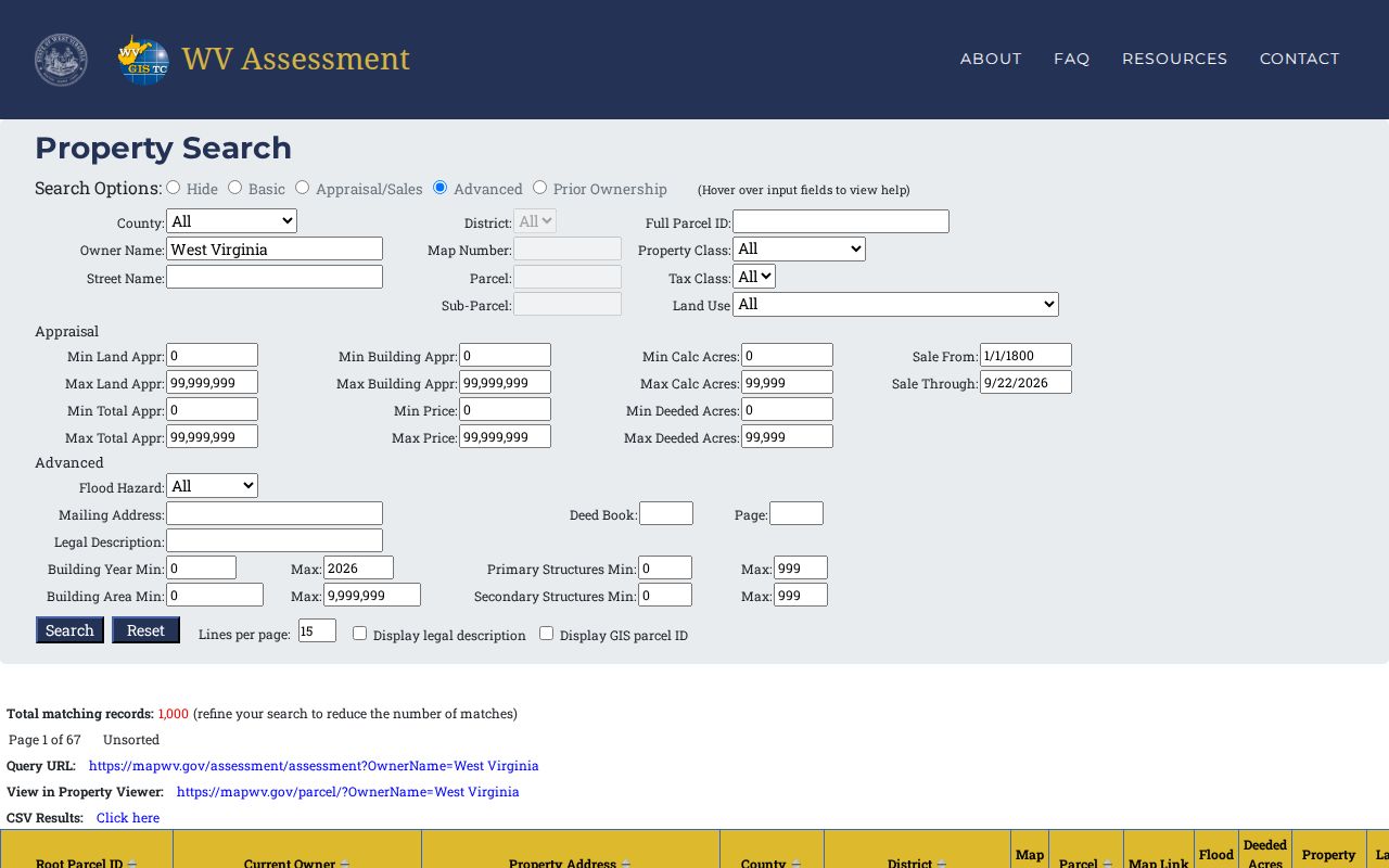
Exported rows are a working index, not a complete census of people at those addresses. For a disputed edge or missing field, ask the county assessor to check its local parcel record.
West Virginia Owner, Situs, and Mailing Addresses
West Virginia property records use separate fields for land, owner, and correspondence. The detailed panel may show the physical address apart from owner information. A tax-roll mailing address can point to another county or state, an entity office, or a representative, so it can help locate the record owner without showing where that person lives.
Three short terms keep the street search clear:
- Situs or physical address
- The place where the parcel sits, often tied to the E-911 address.
- Mailing address
- Where tax notices or owner correspondence are sent; it can differ from the parcel location.
- Parcel ID
- The assessment identifier for a tract, with county, district, map, parcel, and suffix parts.
- Legal description
- The lot, block, subdivision, or metes-and-bounds text that identifies the land conveyed.
West Virginia parcel IDs use district, map, parcel, and suffix segments, with leading zeroes that may be normalized in search boxes. The statewide SAMS/E-911 address and county IAS assessment street field are different search layers. If a street number or label has changed, compare the parcel ID and legal description instead of relying on a mailing city alone.
West Virginia Deed Chain by Street
For a street-wide deed check, use one parcel at a time. Start with the assessed owner, then search the County Clerk index for that owner as grantee near the transfer date. Compare the legal description and prior reference before moving to the seller as the next grantee. Trustee, executor, estate, corporate, or misspelled names may need separate searches.
The Cott county index exposes a similar set of search fields, though exact menus and coverage differ by county:
| Index control | Search or result detail |
|---|---|
| Index type and document kind | Choose a record group such as consolidated real property or a deed, release, lien, or plat. |
| Grantor and grantee | Search both parties, including role terms where shown. |
| Date, book, page, and suffix | Limit by filed date or use a known reference. |
| Description, document number, amount | Use the land text and instrument number to check a likely match. |
| Image or reference | Follow the prior book/page; images may require paid access. |
A deed index result may list:
- Filing date, index type, document kind, and file or instrument number.
- Grantor and grantee names, with trustee or special-party roles when indexed.
- Description, legal acreage or lot text, prior book/page reference, and amount if supplied.
- An image link or thumbnail when that county has online image access.
The West Virginia County Clerk Portal offers guest index access for participating offices. County Certified Dates set the online reach; some counties are moving to RECORDhub, so a search can require accounts on both portals. Image and print charges are posted by the portal, while a certified copy fee is set by the clerk.
Charleston Permits and Address Records
Local records can add dates to an address history, though they do not provide a complete list of residents. Charleston publishes permit classes, but its permit page does not offer public search fields or a posted historical cutoff. A written request should name the address, likely date, work type, and any permit number already known.
Charleston's official call list routes address assignments and annexation requests to 304-348-8105. Building permits and contractor licensing, along with property-code violations, route to 304-348-6833. The permit page lists classes but has no public address-search form or posted historical cutoff. Other West Virginia cities and counties use their own planning, addressing, or code offices.
When a street or municipality label changes, keep the current parcel ID with the older name and ask the local office which map or plat bridges them. The research did not identify one statewide chronology of street renumbering.
Charleston Street Pages in Polk Books
For an older address, a reverse or criss-cross directory may connect a street number to a household for one publication year. The Kanawha County Public Library's Polk Charleston collection runs from 1908 to the present and covers Charleston and nearby suburbs. The volumes must be viewed in the library on the third floor; they cannot be checked out or held.
Older Charleston runs are held by the State Archives and WVU's West Virginia and Regional History Center, while telephone books can preserve rural exchange and community names that a city directory misses. Reverse coverage is uneven, so ask staff for street, address, reverse, or criss-cross sections and record the exact year and publisher.
A directory is a dated residence or business clue, not a deed. The historical volumes and their year runs are treated in more depth on the West Virginia city directory page.
West Virginia Voter Records Near an Address
The free West Virginia voter lookup asks for first name, last name, and date of birth. It does not have a public street field. The result can show registration status, party, districts, and polling place; the page reflects the latest county entry, updates nightly, and may not show same-day activity until the next day.
For broader address sorting, the Secretary of State sells county or precinct voter lists through a request form. The delivered data automatically includes name, residence address, county, party, active status, and registration date. Mailing address, birthdate, and district fields may be requested. The form accepts mail, fax, or email requests and offers spreadsheet, delimited text, or PDF delivery after payment.
Partial lists cost $25 per hour; statewide and election-cycle products have fixed fees listed by the Elections Division. The purchaser certifies the request's lawful purpose. W. Va. Code §3-2-30(f) bars commercial or charitable solicitation and advertising, and resale or reproduction for resale. An address list remains a dated administrative record, not proof that every listed person is at home.
What West Virginia Street Records Miss
A West Virginia street directory can show assessed owners, recorded transfers, a voter entry, or a past address in a directory. It cannot establish every person in a household or confirm current presence. A tax mailing address may point elsewhere, a street record may lag, and one result row may omit additional owners. DMV addresses are restricted under federal law, while utility and delivery customer lists are not public.
Voter lookup and property search also treat protected address data differently. West Virginia's Address Confidentiality Program serves eligible survivors of domestic violence, sexual assault, stalking, and human trafficking through an approved application assistant. Participants receive a substitute address for covered uses, including voter registration. Do not try to infer or expose a protected home address from nearby records.
Lawful use. Use West Virginia address records for personal research, family history, or civic questions, and respect redactions and protected-address rules. Do not use a street search to stalk, harass, or harm anyone.
For one person rather than a whole street, compare the relevant name and address in the record types that fit the question, then confirm uncertain entries with the custodian.